Bangladesh Photo Page: 01 02 03 04 05 06 07 08 09 10 11 12 13 14 15 16 17 18 19 20 21 22 23 24 25 26 27 28


World Heritage Mangrove Sundarbans Tour


Sundarbans National Park

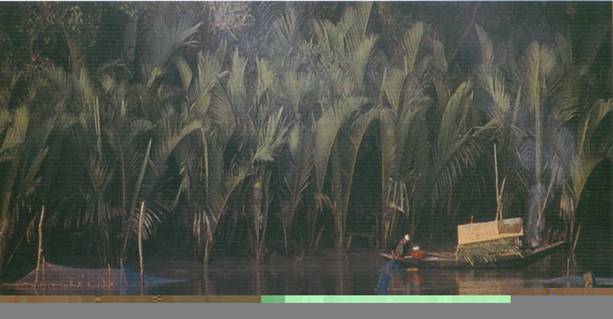
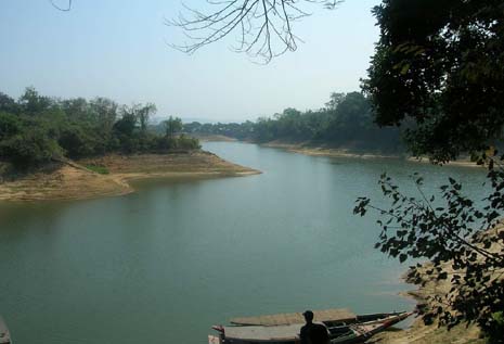
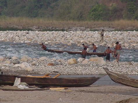
The Sundarbans-the largest continuous blackofmangrove forest in the world -covers in area of 5770sq.km of land and water. It is a part of world's largest delta, which has been formed form sediments deposited by the great rivers Ganges and Bhamhaputra that converge on to the Bengal basin. The western part of the forest lies India and the rest [about 60%] in Bangladesh . River channels and tidal creeks, varying, in width from just a few meters to five kilometers in some places All parts of the Sundarbans forest are subject tidal inundation during spring tides. The Bangladesh part of the forest is dominated by a high mangrove forest cover. The climate is mainly tropical maritime with lots of rain, most of which falls during the monsoon. The monsoon season [May-October] is hot and humid, while winter [October-Feb] is mild and dry. During January temperature can fall as low as 4 deg c.

The entire National Park area is covered by mangrove forest. There are small patches of brackish marshes on emerging islands and riverbanks, and sandy areas with grass and low shrubs on some of the outer islands. The two dominant mangroves are Sundori and Gewa
[ Excoecaria agallocha] 


Sundarbans Inside


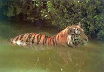
[ panthera Tigri ] .
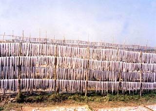

Dry fish


Sundarbans is home to many different species of birds, mammals, and insects, reptiles and fishes. Over 120 species of fish and over 270 species of birds have been recorded in the Sundarbans.The gangetic River Dolphin is common in the rivers, and no less than 50 species of reptiles and eight species of amphibians are known to occur. The Sundarbans now support the only population of the Estuarine or salt -water Crocodile in Bangladesh , and the population is around two hundred individuals.

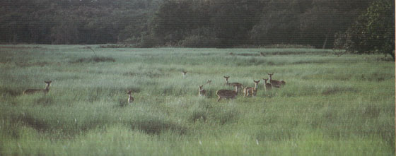
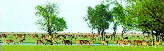
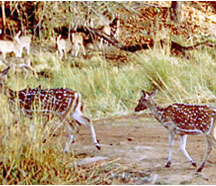
About 32 species of mammal are still found in this forest. Among these are Rhesus Macaques, Clawless, Otters, and Leopard Cats, Fishing Cats and Spotted Deer. The entire Sundarbans Forest comprises the largest remaining tract of habitat for the Royal Bengal Tiger 

Some Bright Moments with The World heritage Sundarbans

The package is towards Sundarban forest that is declared by UNISCO as world Heritage Side, we also have to visit some archeological sides here.


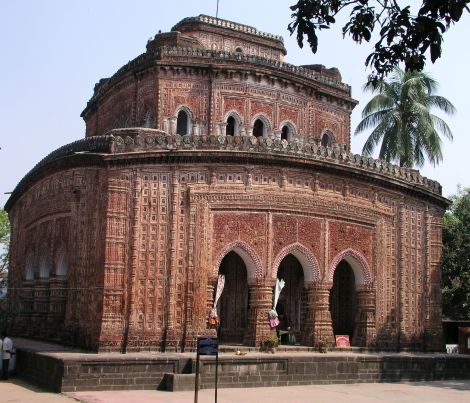
Bengladesh Archeology Tour :


Rajshahi Division

Rajshahi division is in the northern part of Bangladesh has an area of 34513 sq. km and a population of 29.99 million. There are 16 districts and 57 municipalities under Rajshahi. It is famous for archeological and historical sites.

Main Tourist Spots in Rajshahi Division
Mahasthangarh - Paharpur Buddhist Monastery - Kantajee's Temple - Ramshagor Dighi - Shopnopuri - Choto Sona Mosque - Varendra Res c earch Museum - Puthia

Mahasthangarh [Bogra]
Mohasthangarh is one of the main attractions in north Bengal . It was the capital of Kingdom of the Mourjo, the Gupta and the Sen Dynasty.


This is the ancient archeological and historical which was, established in 2500 BC. It is the oldest archaeological site of Bangladesh is on the western bank of river Karatoa 18 km. north of Bogra town beside Bogra-Rangpur Road . The spectacular site is an imposing landmark in the area having a fortified, oblong enclosure measuring 5000 ft. by 4500 ft. with an average height of 15 ft. from the surrounding paddy fields. Beyond the fortified area, other ancient ruins fan out within a semicircle of about five miles radius. Several isolated mounds, the local names of which are Govinda Bhita Temple , Khodai Pathar Mound, Mankalir Kunda, Parasuramer Bedi, Jiyat Kunda etc. surround the fortified city.

A visit to Mahasthangarh site museum will open up for you wide variety of antiquities, ranging from terracotta objects to gold ornaments and coins recovered from the site. Now it is one of the major tourist spots maintained by Bangladesh archeological Department.

You can go to Mohasthanagar from Bogra town, 10 km. away. Don't forget to visit Mohasthangar museum while visiting Mohasthangar. Mohasthan Buddhist Stambho is another attraction for the tourists; it is locally called as Behula's Basar.

Paharpur Buddhist Monastery
Paharpur Buddhist Monastery is another tourist attraction of North Bengal . Paharpur is a small village 5 km. west of Jamalganj in the greater Rajshahi district. You can go to Paharpur from Jaipur district. Its only 10 km from Jaipur.

King Dharma Pal established Paharpur Buddhist Monastery in 7th century, which is the most important and the largest known monastery south of the Himalayas , has been excavated. The main Mandir is in the center of this Monastery. This 7th century archaeological find covers approximately an area of 27 acres of land.

The entire establishment, occupying a quadrangular court, measuring more than 900 ft. externally on each side, has high enclosure- walls about 16 ft. in thickness and from 12 ft. to 15 ft. height. With elaborate gateway complex on the north, there are 45 cells on the north and 44 in each of the other three sides with a total number of 177 rooms. The architecture of the pyramidal cruciform temple is profoundly influenced by those of South-East Asia , especially Myanmar and Java.

A small site-Museum built in 1956-57 houses the representative collection of objects recovered from the area, where you can see the statues of Buddha and Vishnu. The excavated findings have also been preserved at the Varendra Research Museum at Rajshahi. The antiquities of the museum include terracotta plaques, images of different gods and goddesses, potteries, coins, inscriptions, ornamental bricks and other minor clay objects.

Rajshahi City
Rajshahi town is situated besides the river Padma. In monsoon the great Padma is in full spate with its tides and waves whereas in winter it dwindles and you will feel the desert by the side of river. Rajshahi Division is famous for archeological and historical places like Mohastnangor, Paharpur Buddhist Monastery, Kantajee's Temple , Ramshagar Dighi, Choto Sona Masjid, and Shopnopuri etc. You can visit Rajshahi University . It's a very well planed University and you can visit The Shahid Smriti Sangraha Shala in the University, you can see the douments and photography's from the language movement of 1952 to the liberation was 1972. You can also visit Borendra Research Museum . There you will find the ancient elements of Paharpur, Mohasthangar and Mohenjodaro.

Varendra Research Museum , Rajshahi
Situated at Rajshahi, this museum has a rich collection of objects of Mohenjodaro and also of 16th to 19th century A.D. This is devoted to the study of ancient history and culture. Its rich collections contain interesting objects of past Hindu, Buddhist and Muslim heritage. It is located at the heart of Rajshahi town and maintained by Rajshahi University authority. The year of its formal establishment is 1910 A.D.

Puthia
Puthia has the largest number of historically important Hindu structures in Bangladesh . The most amazing of the village's monuments is the Govinda Temple , which was erected between 1823 and 1895 by one of the maharanis of the Puthia estate. It's a large square structure crowned by a set of miniature ornamental towers. It's covered by incredibly intricate designs in terracotta depicting scenes from Hindu epics, which give it the appearance of having been draped by a huge red oriental carpet

The ornate Siva Temple is an imposing and excellent example of the five-spire Hindu style of temple architecture common in northern India . The ornate temple has three tapering tiers topped by four spires. It's decorated with stone carvings and sculptural works, which unfortunately were disfigured during the War of Liberation. The village's 16-century Jagannath Temple is one of the finest examples of a hut-shaped temple: measuring only 5m (16ft) on each side, it features a single tapering tower, which rises to a height of 10m (33ft). Its western facade is adorned with terracotta panels of geometric design.

Puthia is 23km (14mi) east of Rajshahi and 16km (10mi) west of Natore.

Rangpur

Rangpur town, covering an area of around 43 square kilometers, lies on the bank of the Little Ghaghat River , and was turned into a municipality back in 1869 . The population of the Rangpur municipality as of 2006 is 251,699, with 52% male and 48% female, and the literacy rate is 54.6%.

Just south of the city of Rangpur lies the Tajhat , a former "rajbari" or zamindar's palace. After the end of the British Raj, the building was abandoned and decayed rapidly, although it was used for a few years as a courthouse during the 1980's. In the year 2004, it was largely restored and turned into a museum with ancient inscriptions, art and coins from the area on display.

The palace was built by Maharaja Kumar Gopal Lal Roy in the beginning of the 20th century. He was a descendent of a Hindu khatari who emigrated from Punjab . He was a jeweler by profession. It is believed that from the conspicuous appearance of his Taj or jeweled crown his estate derived the name of Tajhat.


Tajhat Rajbari Rangpur

Kantajees Temple [Dinajpur]

Kantajee's Temple is in Dinajpur district. It is the most ornate among the late medieval temples of Bangladesh is the Kantajee's temple near Dinajpur town, which was established in the year 1722 by Ram Nath, son of Maharaja Pran Nath .


Kantajees Temple [Dinajpur]


The temple, a 51' square three storied edifice, rests on a slightly curved raised plinth of sandstone blocks, believed to have been quarried from the ruins of the ancient city of Bangarh near Gangharampur in West Bengal . It was originally a navaratna temple, crowned with four richly ornamental corner towers on two stores and a central one over the third stored. 

Unfortunately these ornate towers collapsed during an earthquake at the end of the 19th century. ln spite of this, the monument rightly claims to bathe finest extant example of its type in brick and terracotta, built by Bengali artisans. The central cells is surrounded on all sides by a covered verandah, each pierced by three entrances, which are separated by equally ornate dwarf brick pillars, Corresponding to the three delicately cusped entrances of the balcony, the sanctum has also three richly decorated arched openings on each face. 


Green Hill Tour

Chittagong:


The second largest city in Bangladesh sits on the bank of the Karnapuli River and has an interesting old waterfront area known as Sadarghat which reflects the importance of river trade to the city's growth. Nearby is the old Portuguese enclave of Paterghatta which remains mostly Christian. The Shahi Jama-e-Masjid and Qadam Mubarak Mosque are two of the most impressive buildings in the city. It's also worth visiting the Ethnological Museum in the Modern City which has interesting displays on Bangladesh's tribal peoples. There are good views and cooling breezes from Fairy Hill in the British City in the north-western sector of the city.

Flights between Dhaka and Chittagong leave three to four times a day, as do the trains, which can take up to seven hours to reach Chittagong. The Dhaka-Chittagong highway is one of the better roads in the country, and there are several bus lines that use it, but the trip can be hairy at times and takes almost as long as the train trip, which is more comfortable and less nerve wracking. Chittagong is 264km (164mi) southeast of Dhaka.


Chittagong Hill Tracts:


Decidedly untypical of Bangladesh in topography and culture, the Chittagong Hill Tracts have steep jungle hills, Buddhist tribal peoples and relatively low density population. The tracts are about 60km (37mi) east of Chittagong, and if it weren''''''''t for the troubles in the region they would be an idyllic place to visit. The region comprises a mass of hills, ravines and cliffs covered with dense jungle, bamboo, creepers and shrubs, and has four main valleys formed by the Karnapuli, Feni, Shangu and Matamuhur rivers. Unfortunately, the region is not entirely safe because of military operations to subdue the tribes'''''''' Shanti Bahini (Peace Army). The troubles stem from the cultural clash between the tribal peoples, who are the original inhabitants of the area, and the plains people, who have begun to develop it. Sick of being displaced, and having their land stolen and encroached upon, the tribal people took to guerrilla warfare in the 1980s to preserve their culture. Getting a government permit to visit the area takes 10 to 14 days in Dhaka.

Rangamati, a lush and verdant rural area belonging to the Chakma tribe, is open to visitors, as is Kaptai Lake. The lake, ringed by thick tropical and semi-evergreen forests, looks like nothing else in Bangladesh. While the lake itself is beautiful, the thatched fishing villages located on the lakeshore are what make a visit really special. Boats that visit the villages leave from Rangamati. Bring your swimming gear because you can take a plunge anywhere.
To get to Rangamati, in the middle of the Hill Tracts, take a train, bus, or plane from Dhaka to Chittagong, and then a bus from Chittagong to Rangmati. It''''''''s about 314km (195mi) from Dhaka to Rangmati.


Tribal Life of Rangamati


Rangamati hanging bridge


Rangamati lake

Once Again with the past

This tour's destination is to visit the interesting tribal culture with our cool forest life with the Chittagong hill districts The tour will bring you once again a back journey towards the past.
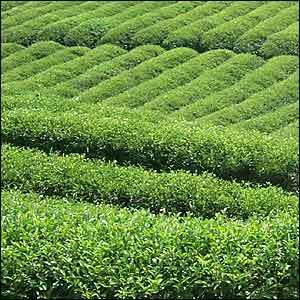
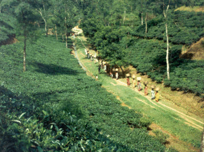
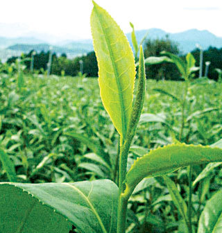

Tea Fresh Tour


Sylhet:

Sylhet division occupies the north east part of Bangladesh , has an area of 12596 sq. km and a population of 7.899 million. There are 4 districts and 14 municipalities under Barisal . It is a natural hilly, forest area with ox bow lakes and famous shrines.

Sylhet City :

Nestled in the picturesque Surma Valley amidst scenic tea plantations and lush green tropical forests, greater Sylhet is a prime attraction for all tourists visiting Bangladesh . Laying between the Khasia and the Jaintia hills on the north, and the Tripura hills on the south, Sylhet breaks the monotony of the flatness of this land by a multitude of terraced tea gardens, rolling countryside and the exotic flora and fauna. Here the thick tropical forests abound with many species of wildlife, spread their aroma around the typical hearth and homes of the Mainpuri Tribal maidens famous for their dance. 

The Sylhet valley is formed by a beautiful, winding pair of rivers named the Surma and the Kushiara both of which are fed by innumerable hill streams from the north and the south. The valley has good number of haors, which are big natural depressions. During winter these haors are vast stretches of green land, but in the rainy season they turn into turbulent seas. 

Sylhet division occupies the north east part of Bangladesh , has an area of 12596 sq. km and a population of 7.899 million. There are 4 districts and 14 municipalities under Barisal . It is a natural hilly, forest area with ox bow lakes and famous shrines.

Sylhet is the land of Shrine 's, natural Hills, forests, beautiful tree plantations and lots of Haors. It is an old city with full of natural beauties. A large number of tourists come every year to visit Sylhet. The main attraction of Sylhet city is the Shrine of Hajrat Shahjalal(R) and Hajrat Shah Poran (R). Shrine of Hajrat Shahjalal (R) is on the top of a hillock (tilla) in Sylhet city. Thousands of visitors are coming everyday in this Shrine. Shrine of Hajrat Shah Paran (R) is eight km far from Sylhet town on the Sylhet-Jaflong road where also thousands of visitors visits this Shrine everyday. Road journey to Sylhet is an wonderful experience through roads running ups and down the hills and green lush tea gardens of nature at its best. 
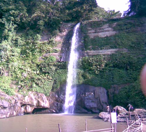

Tea Garden of Srimangal

Water fall sylhet


Jaflong Sylhet


Tea Garden

ALL AROUND THE FRESH AND GREEN
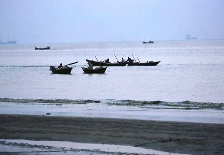
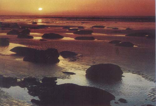
This tour is planed as some dreamy days with all over the green green and green, with the tea Gardens and water falls of Sylhel District .


Blue Sea Tour

Cox's Bazar

Bangladesh 's only beach resort is near the Myanmar border in an area where Rohingya refugees have settled to escape persecution in Myanmar. It has a Burmese Buddhist flavour and few amenities to service the visitors attracted by its enormous expanse of shark-free beach. Even modestly clad bathers, especially females, should expect to be gawked at by locals and Bangladeshi holidaymakers. Bangladeshi women who swim (they are a rare breed) do so in a flowing shalwar kameez . South of Cox's Bazar are more secluded beaches where having a swim can still be a private experience rather than a public spectacle. They include Himacheri Beach and Inani Beach . Note that the beaches are not considered entirely safe at night.


Cox's Bazar sea beach

At the moment the road from Chittagong to Cox's Bazar is one of the worst in the country and still unfinished, but you can avoid it altogether by making your way from Dhaka to Chittagong, and then doing a short 20 minute flight from there. Alternatively buses go straight from Dhaka to Cox's Bazar, a distance of 370km (230mi).

St Martin Island

This small coral island about 10km (6mi) south-west of the southern tip of the mainland is a tropical cliché, with beaches fringed with coconut palms and bountiful marine life. There''s nothing more strenuous to do here than soak up the rays, but it''s a clean and peaceful place without even a mosquito to disrupt your serenity. It''s possible to walk around the island in a day because it measures only 8 sq km (3 sq mi), shrinking to about 5 sq km (2 sq mi) during high tide. Most of island''s 5500 inhabitants live primarily from fishing, and between October and April fisher people from neighbouring areas bring their catch to the island''s temporary wholesale market. A ferry leaves Teknaf for St Martin every day and takes around 3 hours.

Getting to St. Martin''s is a three-step program. First you''ll need to fly or bus it down to Cox''s Bazar, and then catch a bus to Teknaf, which is right on the very tip of Bangladesh, sandwiched up against Myanmar. From Teknar, ferries run daily to St. Martin Island. The total distance from Dhaka to the island is 510km (316mi).


Corals of the Saint Martin Island

WHERE THE FRIENDSHIP OF SKY AND SEA

The nature has a lot of secrets and moods. Men love friendship may be nature also. To see the friendship of sky and see we will bring you Cox's Bazar the largest unbroken sea breach of the world.


Bangladesh Photo Page: 01 02 03 04 05 06 07 08 09 10 11 12 13 14 15 16 17 18 19 20 21 22 23 24 25 26 27 28


All right reserved by Abohomanbangla.com